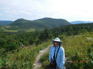
A 30 minute drive in the car to the Gaspesie National Park where we spend the day. Located in the center of the Gaspe Peninsula, the park is huge with 802 square kilometers and includes 25 mountains of a height over 1000 meters plus many more the are under that figure. We hiked the La Saillie Trail, a 3.4 kilometer hike with 190 meter in elevation gain. After 2 days of no hiking, we thought our legs would have recovered from the hiking we did in Forillon NP but we discovered our legs were still tired. We persevered and reached the viewpoint 10 minutes ahead of the parks estimated time. The downhill return was a piece of cake. A second hike was a shorter one to the Chute (waterfall) Sainte-Anne, a 1.7 kilometer hike of ups and downs along the Sainte-Anne River. We ate our packed lunch inside the Visitor Center which had an inside room with a view. We then drove abut 20 minutes on a dirt road to the Le Mont Ernest-Laforce trail head. This was a 4.5 kilometer hike with 155 meter elevation gain. It sure seemed a lot more than that. The trail to the summit was all uphill and was very taxing but we made it to the top with a fantastic 360 degree view of the Gaspesie Appalachian Mountains not to mention a very cool breeze. There was a crowd at the top initially but then we found ourselves alone which was wonderful. I did not want to leave due to the beauty of the moment and maybe due some to avoidance of more hiking. Fortunately, the rest of the hike was all downhill. We returned to the coach about 5:30 and chose not to walk the campground and beach that evening.
Tuesday, August 21, 2018
Day 27, Tuesday, August, 21, 2018. Sainte-Anne-Des-Monts, QC
A 30 minute drive in the car to the Gaspesie National Park where we spend the day. Located in the center of the Gaspe Peninsula, the park is huge with 802 square kilometers and includes 25 mountains of a height over 1000 meters plus many more the are under that figure. We hiked the La Saillie Trail, a 3.4 kilometer hike with 190 meter in elevation gain. After 2 days of no hiking, we thought our legs would have recovered from the hiking we did in Forillon NP but we discovered our legs were still tired. We persevered and reached the viewpoint 10 minutes ahead of the parks estimated time. The downhill return was a piece of cake. A second hike was a shorter one to the Chute (waterfall) Sainte-Anne, a 1.7 kilometer hike of ups and downs along the Sainte-Anne River. We ate our packed lunch inside the Visitor Center which had an inside room with a view. We then drove abut 20 minutes on a dirt road to the Le Mont Ernest-Laforce trail head. This was a 4.5 kilometer hike with 155 meter elevation gain. It sure seemed a lot more than that. The trail to the summit was all uphill and was very taxing but we made it to the top with a fantastic 360 degree view of the Gaspesie Appalachian Mountains not to mention a very cool breeze. There was a crowd at the top initially but then we found ourselves alone which was wonderful. I did not want to leave due to the beauty of the moment and maybe due some to avoidance of more hiking. Fortunately, the rest of the hike was all downhill. We returned to the coach about 5:30 and chose not to walk the campground and beach that evening.
A 30 minute drive in the car to the Gaspesie National Park where we spend the day. Located in the center of the Gaspe Peninsula, the park is huge with 802 square kilometers and includes 25 mountains of a height over 1000 meters plus many more the are under that figure. We hiked the La Saillie Trail, a 3.4 kilometer hike with 190 meter in elevation gain. After 2 days of no hiking, we thought our legs would have recovered from the hiking we did in Forillon NP but we discovered our legs were still tired. We persevered and reached the viewpoint 10 minutes ahead of the parks estimated time. The downhill return was a piece of cake. A second hike was a shorter one to the Chute (waterfall) Sainte-Anne, a 1.7 kilometer hike of ups and downs along the Sainte-Anne River. We ate our packed lunch inside the Visitor Center which had an inside room with a view. We then drove abut 20 minutes on a dirt road to the Le Mont Ernest-Laforce trail head. This was a 4.5 kilometer hike with 155 meter elevation gain. It sure seemed a lot more than that. The trail to the summit was all uphill and was very taxing but we made it to the top with a fantastic 360 degree view of the Gaspesie Appalachian Mountains not to mention a very cool breeze. There was a crowd at the top initially but then we found ourselves alone which was wonderful. I did not want to leave due to the beauty of the moment and maybe due some to avoidance of more hiking. Fortunately, the rest of the hike was all downhill. We returned to the coach about 5:30 and chose not to walk the campground and beach that evening.
Subscribe to:
Post Comments (Atom)


No comments:
Post a Comment